
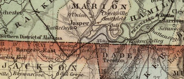
From an 1852 map of northern Alabama and Georgia and southern Tennessee. http://www.davidrumsey.com
On a lovely day last month, I was driving home from Chattanooga and decided to take a detour off I-24, to satisfy a simple, geeky desire to stand at the precise point that divides Tennessee from Alabama and Georgia, as well as Eastern from Central Time. “I know I’m not the only one who gets this liminal thrill from standing on borders,” writes Ken Jennings in his 2011 book, Maphead, before going on to note that 200K+ tourists a year visit the Four Corners monument, to see where the states of Utah, Arizona, New Mexico, and Colorado all meet. For some reason, I wanted to gaze upon the spot nearby where geographical abstraction triumphs over topographical realities.
There was another reason I wanted to go there, though, one a little more timely. At the very place where the three states meet is the point where the state of Georgia is about a hundred feet from Nickajack Lake, the body of water formed by a TVA dam on the Tennessee River. The border has been much in the news lately, ultimately because of global warming. In the past few years, drought conditions in the South have worsened and state governments have been looking for new sources of water as a result. The large metropolis of Atlanta has a particularly acute problem, water-wise, and so Georgia has turned a thirsty eye to its northern border. Naturally, Tennessee has no interest in ceding any part of the river to Georgia.
Lines arbitarily drawn on the land that end up unexpectedly significant? Pissed off politicians? Water rights in dispute? All of this was just too Chinatown to be missed, so I took exit 161 off I-24 to see what was what. Besides, there might be a cool little marker I could take a picture of.
 The Federal Georgia Road south of Lake Nickajack is easy to find–just look for the exit to Big Daddy’s Fireworks (“Best ‘Bang’ For Your Buck”). It’s an old road, constructed between 1805 and 1808 according to the historical marker by the roadside, in order to connect Tennessee to the Atlantic seaboard. On the map it’s called TN-156, but the local signs along the way read Old Ladd’s Road and, further on, Shellmound Road. It’s worth noting that most of this area was in Cherokee hands at the time the Federal Road was constructed, and they had roads of their own running through it.
A few miles on, I’m looking to take a left onto what the GPS is calling Macedonia Road. Why Macedonia, I wonder? Surely, at this place of dispute between borders there isn’t a subtle reference to the geographical problems of the former Yugoslavian republic of Macedonia, which the Greeks insist should be called Skopje? But again, local realities clear the matter up. It’s Macedonia Church Road, a reference to the people of Phillippi, whose church was founded by St. Paul after he’d had a dream: “And a vision appeared to Paul in the night; There stood a man of Macedonia, and prayed him, saying, Come over into Macedonia, and help us” (Acts 16:9 KJV). I don’t know how old the Macedonia church here in Shellmound is, but probably it was founded as a mission to the Indians. Interestingly enough, the Pauline vision, together with an Indian, features in the the oldest American emblem, the state of Massachusetts’ first seal.
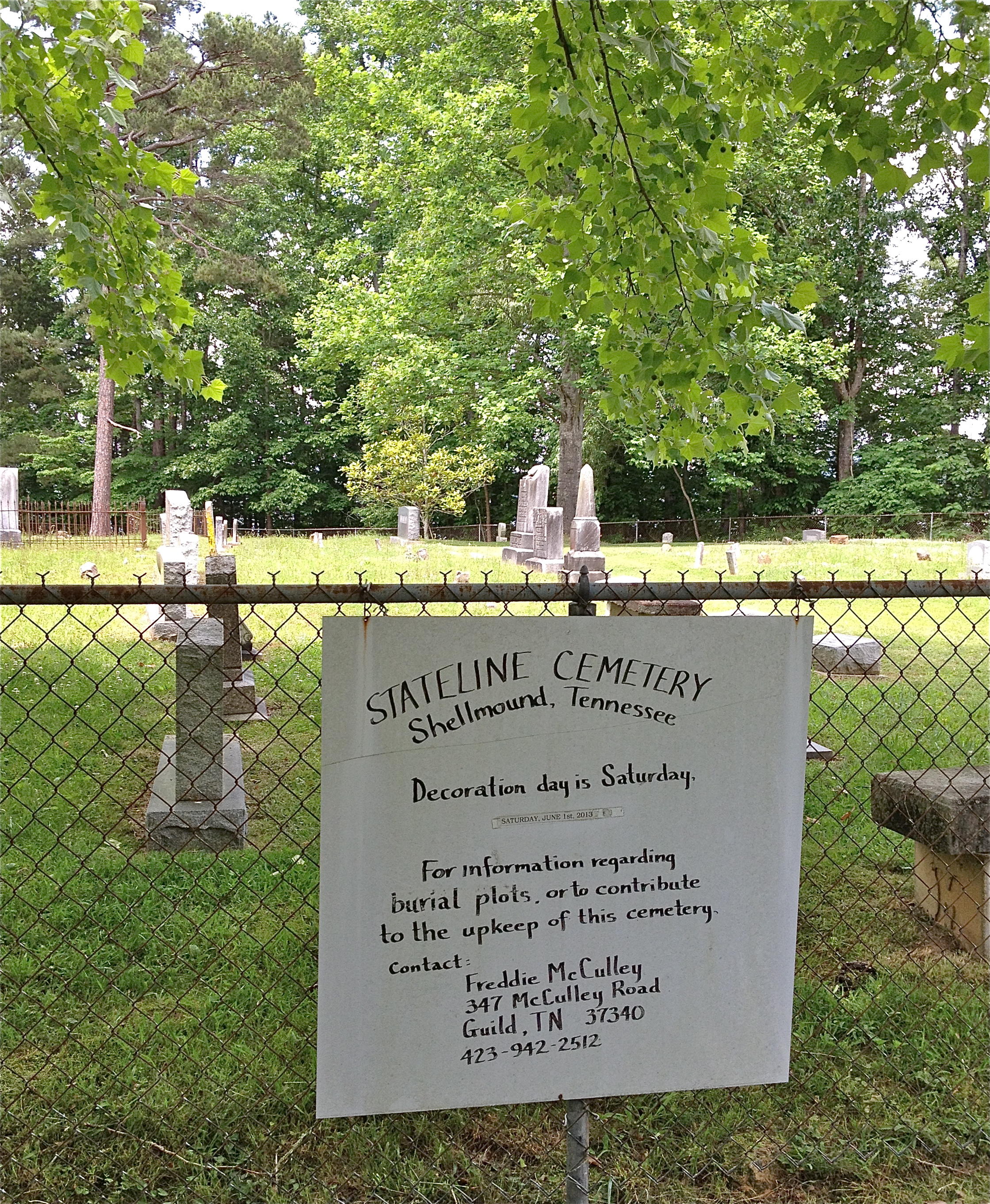 At the end of Macedonia Church Road, it’s a little hard to figure out which way to go, but a sign pointing to State Line cemetery seems like a safe bet. There’s an abandoned school bus in an overgrown lot in the other direction which I’m glad enough to avoid. I drive down a long straight street, Huckabee Lane, which, as it happens is the line dividing Georgia from Tennessee. On the TN side is the old graveyard, with a sign noting “Decoration Day is Saturday, June 1st, 2013.” Decoration Day (as opposed to Memorial Day, which takes place on the last weekend in May), is a tradition going back to the commemoration of the Confederate dead right after the Civil War. It is intriguing to see here the persistence of this local custom, even a century and a half after the war.
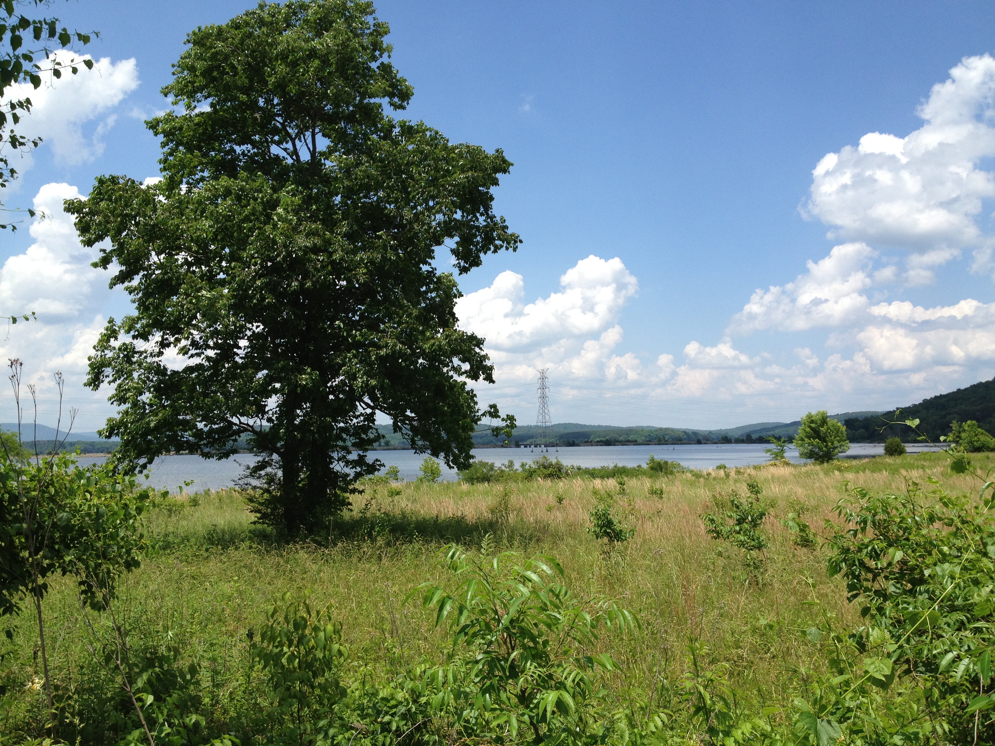
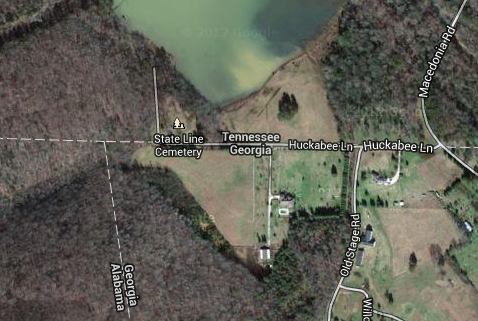
Just before the cemetery is this pretty patch of land, the bone of contention between the states. The screen-shot from Google Maps below shows what’s at stake–my photo above was taken from the Georgia side of Huckabee Lane, but the tree just a few dozen feet away is in Tennessee. Behind the tree, also in Tennessee, is Lake Nickajack. Look at all that water. Sweet, sweet water that Atlanta would desperately like to get its parched little mitts on.
As a matter of course, rivers make good borders: Canada is on one side of Rainy River, for instance, while Minnesota is on the other. Between Texas and Mexico runs the Rio Grande. The same is true of state boundaries, of which many examples can be given. The Connecticut River divides Vermont from New Hampshire, while the Ohio River separates Illinois, Indiana, Kentucky, and West Virginia from the state that bears its name. Good fences make good neighbors, Robert Frost reminds us. On the other hand, though, the sense of competitiveness that exists between those having to share a body of water has given rise to the English word “rival,” from the Latin word rivalis, describing one who lives on a river bank.
At this very point on the map, in the original sense of the world, Georgia and Tennessee are not rivals, because they do NOT in fact share the river. And yet, they should, as Georgia never tires of pointing out. In 1818, a mathematician named James Camak was hired to survey the boundary line dividing Tennessee from Georgia which, according to the Articles of Agreement and Cession dealing with the dispensation of lands formerly in the Mississippi territory, ought to have been the 35th parallel. Camak did the best he could with the instrument he had at hand, a nautical sextant, but nonetheless ended up drawing the line too far to the south.
And there the boundary has stood ever since. A bill that has been overwhelmingly passed this year in both chambers of the Georgia legislature demands that the line stipulated by the treaty be respected (the entire resolution, Georgia HR 4 2013-2014, can be viewed here and here), and they are threatening to take the issue to the Supreme Court. It’s doubtful, though, that the court will redraw so long established a border line.
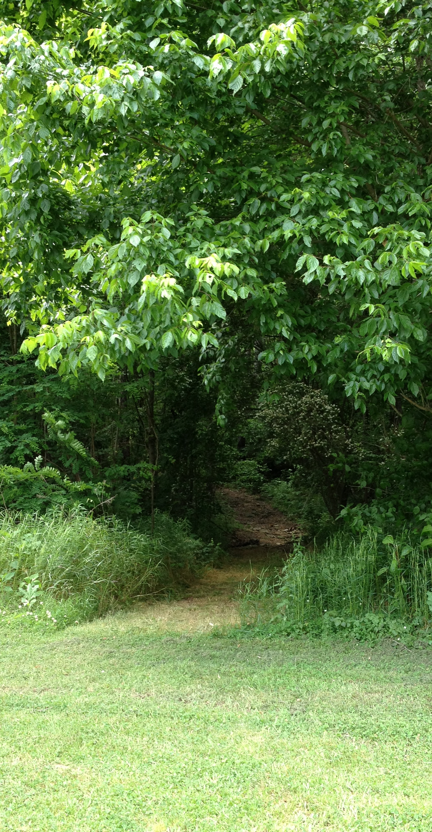 Talking of which, I wanted to see the boundary itself. End of the street. Up ahead is a path, which looks like it’s just crawling with ticks, chiggers, poison ivy, and snakes. And I think I hear banjos. (Seriously, Deliverance takes place on north Georgia river). On the other hand, it’s clear enough where you’re supposed to go. There are a few nice houses around with pristine lawns, and not a single dog has come out and growled at me. I probably won’t be down this way again very soon, so I pick up my iPhone, open the cardoor, and head for the trailhead.
Just a few feet in, it’s clear that in my shorts and sandals, I’m not suitably dressed for this outing. The path is close and overgrown, with lots of thorny things unavoidably growing on either side. In addition, the path has divided itself into a several smaller paths. I take out my phone and check Google maps, thinking to myself that James Camak could really have used an iPhone and GPS two centuries ago. But after a little while I realize that the little satellite-derived “you are here” arrow is only getting me so close to where I want to be. Maybe I would be better off with a sextant, after all.
I’m beginning to lose heart when I look up and see a piece of orange cloth tied to a branch. Well, I think, it’s probably there for a reason. What Apple cannot manage to do, a simple rag somehow has no problem with: showing me the way.
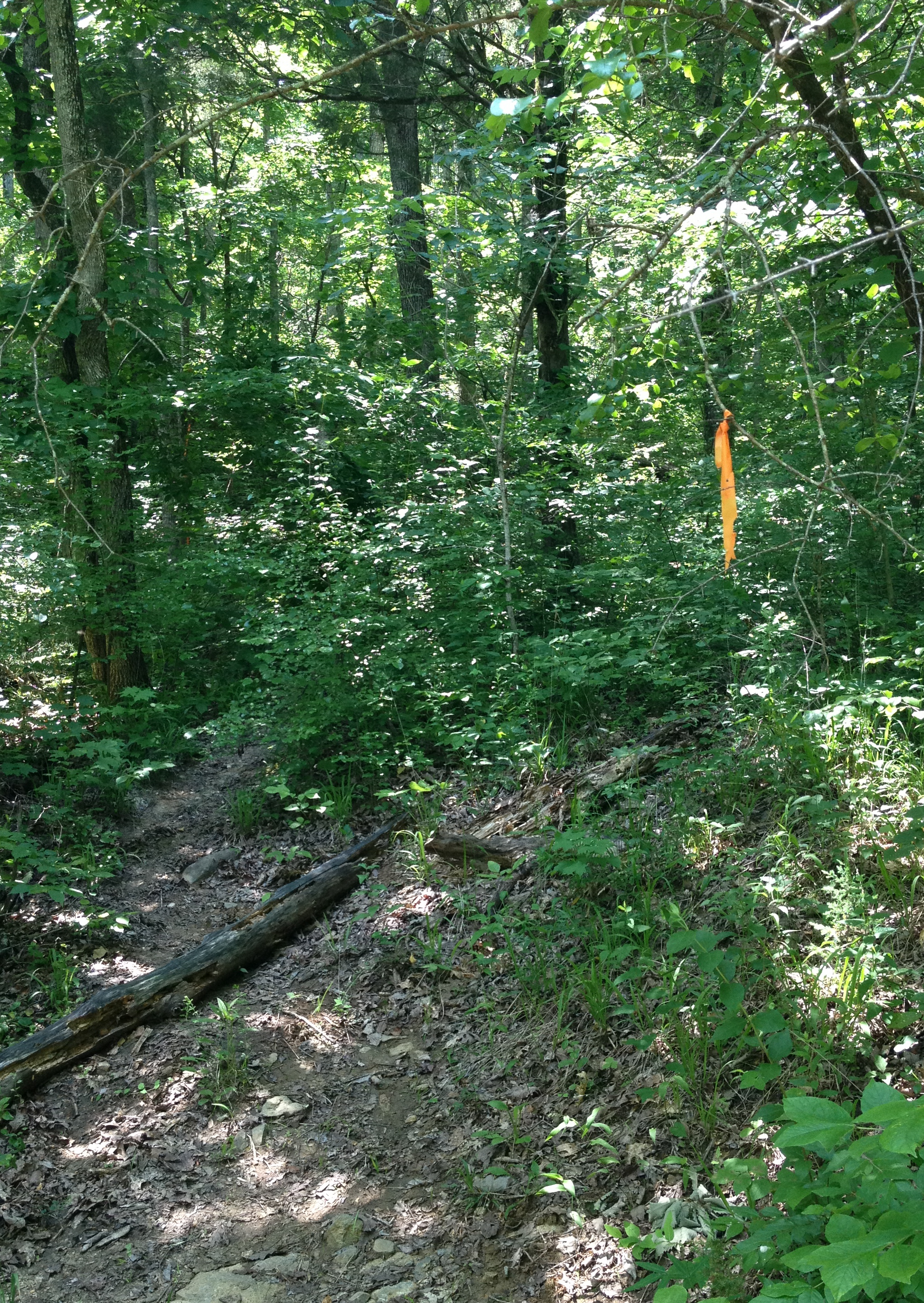
Climbing along a really thick bit of path, I’m feeling something like Indiana Jones, looking for a hidden temple in the middle of an Amazonian jungle. And then, I spot it …


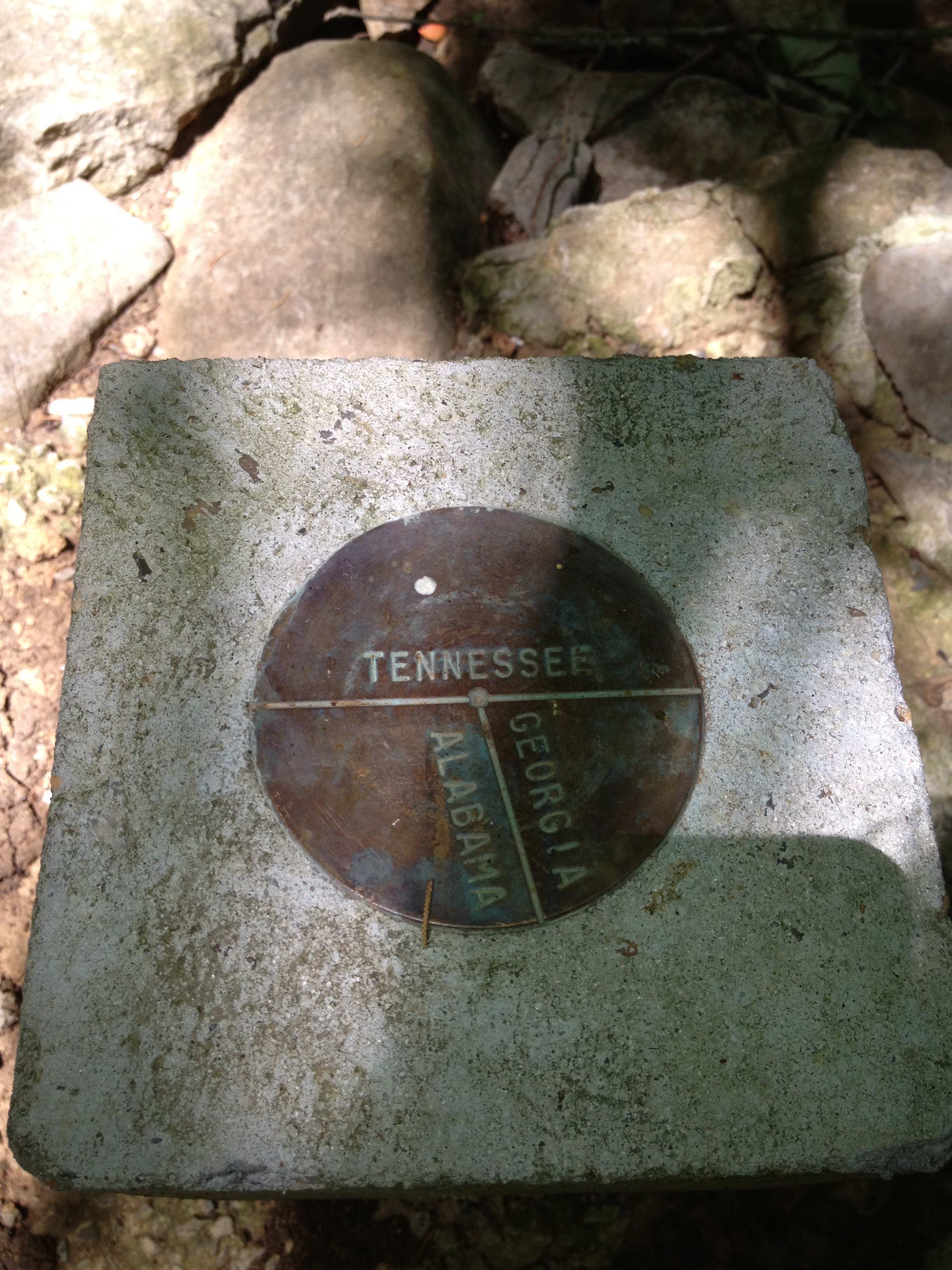
… the cool little marker I’d come all this way to see. The medallion is only about 4 inches in diameter and buried in the middle of a bunch of poison ivy, but it represents a geographical error two centuries old that has aggravated state politicians ever since. For the South’s largest city, it means a world of water-related trouble that climate change will only exacerbate.

wow.
This is an incredible post… you went where politicians and historians talk about, but how many get out of the car?
I bet fewer than 2,000 tourists come to see this marker every year. Thanks for the informative article.
My family has lived in this area for generations, in all three of these states, usually only a stones throw from each other. I will find this marker on my next trip to clean an old cemetery in the area that most of the family seems to have forgotten.
Thank you for your remarks, Shirley. Is the old cemetery different from the State Line cemetery?
Pingback: A Marian Shrine in Marion County | uncomelyandbroken
Pingback: How to stand in Tennessee, Georgia and Alabama at the same time | David Carroll's Chattanooga Radio and TV